 If I ask an elevation surveyor near me what types of tech they use to do their work, chances are they’ll need to take a long time to list all the hardware and software they have in use. In terms of specialized technology, it’s important to mention such devices as accurate telescopes or electronic distance measurement (EDM) tools which have been in use for a long time, but the truth is that the technology has evolved to an impressive extent in recent years.
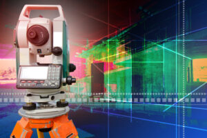
Nowadays, you’ll hear such terms as Global Navigation Satellite System, Surveying Robots and high speed LIDAR and laser scanning. Even remote sensing technology is a reality today, and it’s becoming more and more advanced, as surveyors have the ability to use it for obtaining highly accurate information about the land they’re surveying.
Computer technology can’t be left out from here either. In the past, land surveyors made the measurements the old fashioned way and had no quick means of comparing and researching survey information. These days ILC Denver experts use advanced software available to them to get answers at the touch of the button and speed up their work a great deal. CAD modeling and various other methods of 3D visualization and survey data management also help with creating a clearer picture of the land that’s being surveyed and ensuring that the conclusions gathered upon its analysis are as accurate as possible.
For convenience’s sake, they also make use of portable computers and tablets, as well as devices that enable easy communication over sizable distances, such as wireless modems and routers.